

Lofoten, Norway
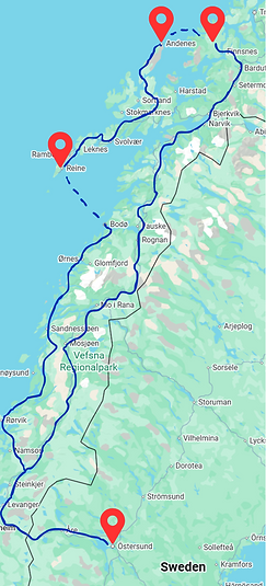
The Lofoten Islands, a dramatic archipelago in northern Norway above the Arctic Circle, are world-renowned for their towering mountains that rise straight from the sea, deep fjords, and traditional red fishing cabins known as "rorbuer".
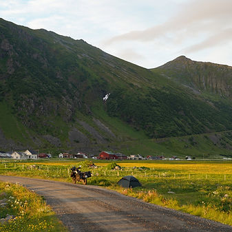
I rode approximately 2,500 km from Östersund in Sweden, following the coastline all the way to Bodø. From there, I took a ferry to Moskenes and rode to Å, the very tip of the Lofoten peninsula, and explored some of the most breathtaking places on my bucket list all over the Archipelago. Although the weather wasn’t always on my side and forced me to cancel a few plans, the experience was still incredible.
Continuing inland, I made my way north to Andenes to visit a whale watching center Whalesafari Andenes where my father once worked. It was a special moment—returning to a place I had visited as a baby, and meeting people who remembered holding me nearly 29 years ago.
From there, I took another ferry to Senja and rode across its vast, rugged landscapes before heading back south toward Sweden.
Nasjonal Turistveg Helgelandskysten
The Helgeland Coast National Tourist Route (fv. 17) is a 433 km long, spectacular driving route through Nordland, known as one of the most beautiful in the world. The route runs from Holm in the south to Godøystraumen in the north, involves six ferry crossings, and offers dramatic mountains, thousands of islands, and attractions such as Torghatten, The Seven Sisters and Svartisen.


Ferry system
The vast majority of Norwegian ferries operate on a first come, first served basis. You do not need to buy a ticket in advance, and there is for the most part no ticket reservation ahead of time. Ticket prices can be looked up here. For most ferries, this is not a problem, however some distances very popular among tourists might have long queues in high season.
For Bodø to Moskenes (Lofoten), a popular connection, especially during tourist season. Advance booking of the reservation is recommended if you plan to travel with this ferry in the period from May to September. The reservation costs 250 NOK, I bought my ticket here.
Nesna
If you take the ferry from Levang ferjekai to Nesna and continue on the road Kystriksveien there are so many beautiful camping spots you can find once you start coming up on the mountain road. I found one over looking Nesna and it was the perfect spot for me. If you go a little further you will find a tunnel through the mountain. Right after the tunnel there is a large opening to the ocean, Leirbakkan strand, where I stopped for a break and this could easily also be a great camping spot.
Wild camping in Norway is generally legal under the "Allemannsretten" (Right to Roam) law, allowing you to pitch tents on uncultivated land. Key rules include staying at least 150 meters from inhabited houses/cabins, a maximum two-night stay in one spot, and leaving no trace. Motorized vehicles cannot go off-road, and open fires are banned from April 15 to September 15.


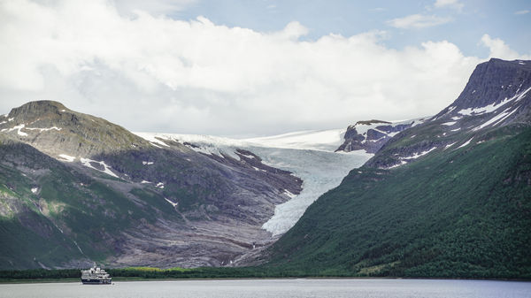
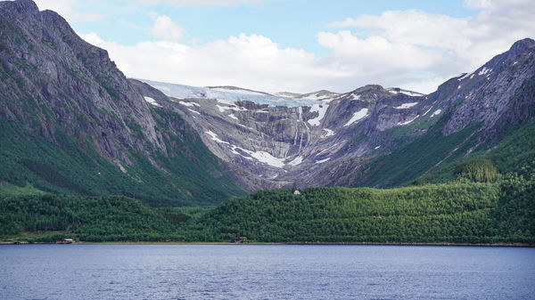
Svartisen
Svartisen is Norway's second-largest glacier, covering approximately 370 square kilometres. It consists of two separate glaciers, Østisen and Vestisen, separated by a valley.
I continued on the road north to Kilboghamn and took the ferry to Jektvik which was when I passed the line to the Artic Circle. Then rode to the next harbor, Ågskardet and took the next ferry to Forøy. From there it was a short ride to Braset Lookout where you could see the two glaciers.
Contrary to a literal translation, the name doesn't mean "black ice" in a dirty sense. The name comes from the old Norwegian word "svartis," which describes the incredibly dark, deep blue colour of the old, highly compressed glacial ice.


_edited.jpg)
Å : The tip of Lofoten
Å (pronounced like the English word "awe") is a uniquely preserved fishing village located at the southernmost tip of the Lofoten archipelago on the island of Moskenesøya. It is famous for having one of the shortest place names in the world and marks the official end point of the European route E10 highway.

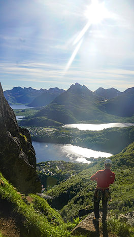
Reinebringen
Reinebringen is a legendary hike in the Lofoten Islands, famous for offering a breathtaking panoramic view of the village of Reine, the turquoise Reinefjorden, and the sharp peaks of the "Lofoten Wall".
Essential Hike Details (2026)
-
Distance: Approximately 2.0 km to 2.4 km round-trip.
-
Duration: Typically 1.5 to 3.5 hours round-trip, depending on your fitness and how long you spend at the top.
-
Elevation Gain: Roughly 448 to 484 metres.
-
Terrain: A relentless ascent of 1,978 Sherpa-built stone steps. The steps end about 50 metres below the summit, followed by a steep, often muddy path to the final viewpoint
This hike was hands down so brutal and my legs were literally shaking. But it was SO WORTH IT for the view and I highly recommend that you try it!
_edited.jpg)


Fredvang
Fredvang Camping (officially Fredvang Strand- og Skjærgårdscamping) is a large, budget-friendly campsite located on the outer coast of Moskenesøya. It is highly regarded for its stunning location directly on a white sandy beach with views of the Midnight Sun.
Facilities and info:
-
Basic amenities including WCs, showers (approx. 19 NOK for 5 minutes), and laundry facilities.
-
A small kiosk, TV room, and a communal kitchen (quite small).
-
Hiking: The campsite is an ideal base for the famous Ryten hike, which offers a cliffside view of Kvalvika Beach.
-
There are no grocery stores in Fredvang; the nearest shops are in Ramberg (approx. 10-15 min drive), so stock up before you arrive.

Haukland Beach
Haukland Beach (Hauklandstranda) is frequently voted as Norway’s most beautiful beach and is a "must-visit" on the island of Vestvågøy. Its white coral sand and crystal-blue water look tropical, though the water temperature rarely rises above 12°C.
Key Features
-
Accessibility: Unlike many Lofoten beaches that require a hike, Haukland is right off the road with a large parking area.
-
Midnight Sun: Facing north-west, it is one of the premier spots in Lofoten to watch the Midnight Sun (late May to mid-July).
-
Facilities: There is a small café (seasonal), toilets, and an outdoor shower.
You are not allowed to camp here with a tent but motor homes can pay a fee to stay over the night.


Unstad
Unstad Beach is one of the most famous and scenic cold-water surf spots in the world, located in the arctic circle. Enclosed by steep, snow-covered mountains, the beach features a sandy middle section with dramatic boulders lining the sides.
This beach was perfect for watching the midnight sun. That day was not raining and the sun just touched the horizon on the water and then came back up again. It was a really cool experience to see that. There was also plenty of camping space.
To get to the beach you also pass this beautiful outlook over the ocean and the mountains and even if you don't stay in Unstad it is worth the ride for that view.

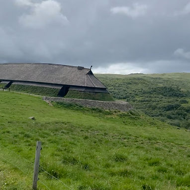
Lofotr Viking Museum
The Lofotr Viking Museum (located in Borg on Vestvågøya) is a living history museum built around the archaeological site of the largest Viking longhouse ever discovered.
Museum Highlights
-
Reconstructed Longhouse: Step inside a full-scale, 83-metre-long chieftain's house, where you can smell woodsmoke and see craftspeople at work.
-
Interactive Exhibits: The modern visitor center houses archaeological finds like imported glass and gold, with audioguides available on your smartphone.
-
The Harbour: A 20-minute walk from the longhouse takes you to a Viking ship replica where you can row or sail during the summer months.
-
Viking Activities: Try your hand at archery, axe-throwing, or horse riding (offered mainly from June to August).
My absolute favorite part of the museum was the sailing on the viking ship which is manned by viking sailors. The whole ship runs solely on wind power in the sails which was really cool to see.
_edited_edited.jpg)
_edited.jpg)
_edited.jpg)
_edited.jpg)


Festvågtind
The Festvågtind hike is a short but strenuous ascent in the Lofoten Islands, famous for its 360-degree panoramic views of the fishing village of Henningsvær and the surrounding sea. While only about 1.3 km to 3 km round trip, it is rated as demanding or hard due to its sustained steepness and technical terrain.
I would have to say it was one of the more technical hikes I've done due to it being just a mud path with loose rocks and an almost vertical ascend. I'd say I'm average when it comes to fitness but this was really challenging for me.
Hike Overview
-
Difficulty: Demanding/Hard. It is a steep, rocky climb that often requires the use of hands for balance (clambering/scrambling).
-
Time: Roughly 2 to 3 hours for the round trip.
-
Elevation Gain: Approximately 541 metres.
-
Best Season: May to October (snow-dependent). Summer offers the best conditions and the chance to see the Midnight Sun from the peak
Svolværgeita
Svolværgeita (The Svolvær Goat) is a world-famous, 150-metre-tall granite pinnacle towering above the town of Svolvær in the Lofoten Islands. It is most iconic for its "horns"—two distinct rock pillars at the summit—and the daring tradition of jumping between them. The jump is however not allowed anymore due to the risk of boulders falling down on the homes below the mountain.
For those looking to climb Svolværgeita, professional guiding services are highly recommended, especially for beginners. Most tours take between 3 to 5 hours and provide all necessary technical gear like helmets, harnesses, and climbing shoes.
I chose to climb with I Fri Natur which was a great tour company to climb with. I've climbed outside before, but this was something else. We were three people in our group but the guide was able to get all of us up in one piece. We were so lucky with the weather and had an amazing sunny day all day. I highly recommend doing this if you enjoy climbing or an adrenaline rush!


Andenes
Andenes is a historic fishing village on the northern tip of Andøya island, renowned as Norway's premier destination for year-round whale watching.
Andenes is one of the world's best locations for whale watching (hvalsafari) because the deep-water Bleik Canyon is located just offshore. As currents hit the steep walls of the canyon, they force cold, nutrient-rich water from the abyss up toward the surface. These nutrients trigger a bloom of plankton, which attracts massive schools of fish and deep-sea cephalopods (squid) which is the primary food source for sperm whales. In most parts of the world, the continental shelf is dozens or hundreds of kilometers out at sea. At Andenes it's just 10 - 15 km from the coast.
_edited.jpg)


Because of the weather I wasn't able to see the whales, but the whale safari has another meaningful part of my journey. My dad used to be a marine biologist and did a lot of research on the whales in Andenes. My mom brought me up to the research facilities once as a baby and I got to go on the whale watching boat.
I now returned 29 years later to see if anyone at the research center still remembers my dad. I met Tiu Similä, who worked with my dad at that time and also met me as a baby. She showed me a poster she still has in her office where my dad is one of the whales. She also gave a guided tour of the whale museum which I highly recommend!

Senja
Senja, often called "Norway in miniature," is famous for its dramatic fjäll (mountains) that rise straight out of the turquoise fjords. Unlike the more crowded Lofoten Islands, Senja offers a raw and quieter Arctic mountain experience.
At this point during my travels the weather was really cold and rainy and I decided to ride rather fast over the roads here. But it is a very beautiful riding route through the mountain landscape and if you're not afraid of the cold I say give it a go!
